The Sound of Deforestation, A Hack to Make Data Sing
In his lightning talk Lagomasino proposed a challenge to help study deforestation by linking satellite imagery and ground-images gathered via crowdsourcing

In his lightning talk Lagomasino proposed a challenge to help study deforestation by linking satellite imagery and ground-images gathered via crowdsourcing
Scientists for the first time have simultaneously compared widespread impacts from two of the most common forest insects in the West—mountain pine beetle and western spruce budworm – an advance that could lead to more effective management policies.

The rate at which tropical forests were cut, burned or otherwise lost from the 1990s through the 2000s accelerated by 62 percent, according to a new study which dramatically reverses a previous estimate of a 25 percent slowdown over the same period. That previous estimate, from the U.N.’s Food and Agriculture Organization’s (FAO) Forest Resource Assessment, was based on a collection of reports from dozens of countries. The new estimate, in contrast, is based on vast amounts of Landsat image data which directly record the changes to forests over 20 years.
When viewed from space, clouds largely obscure the Earth. It isn’t a matter of time of day, angle or distance. It’s just the way it is – unless, of course, you are gazing at the planet using Google Earth. The story of how Google Earth offers images of the planet — without letting clouds get in the way — began in the foothills of the Santa Cruz Mountains in California.
Each year the U.S. Forest Service takes a census of trees, chronicling the nation’s forest heath and timber resources. Forest managers use this information to project what U.S. forests will be like in coming decades and, if needed, to adjust their forest management practices in order to safeguard sustainability.
Along the sea’s edge in Bangladesh, India, Pakistan, and Sri Lanka, the dense coastal population lives largely in symbiosis with the region’s mangrove forests.
Mangroves—a vast network of intertidal trees and shrubs with their characteristic tangle of above ground roots—give safety, sustenance, and spectacle to coastal denizens in a multitude of ways. Namely, by stabilizing shorelines, safeguarding water quality, influencing stable microclimates, controlling flooding, and providing transportation, forest products, hunting and fishing grounds, and recreation and protecting people and property from storms.
A group of researchers from the University of Maryland, the Indonesian Ministry of Forestry, and the World Resource Institute joined forces to remedy the lack of consensus about the amount of old-growth forest clearing occurring in Indonesia.
This 1977 NASA video series, “Landsat—Satellite for All Seasons,” provides examples of early Landsat applications.
Cold-sensitive mangrove forests have expanded dramatically along Florida’s Atlantic Coast since the mid-1980s, as the frequency of killing frosts has declined, according to a new study based on 28 years of satellite data from the NASA-USGS Landsat program.
Forest conservation is an issue of major concern to communities large and small around the globe. But gathering the monitoring data needed to make the right decisions has proven extremely prohibitive for individuals to entire governments.
A new way of studying and visualizing Earth science data from a NASA and U.S. Geological Survey satellite program is resulting in, for the first
• NASA’s Earth-observing fleet of satellites provides a worldwide and unbiased view with standardized scientific data—information crucial for tracking the health of the world’s forests.
Kirtland’s warblers are an endangered species of lightweight little birds with bright yellow-bellies that summer in North America and winter in the Bahamas. But be
The widespread Aspen mortality, caused by a severe five-year drought and higher temperatures, could have major implications for regional carbon cycles.
Contributor: Melissa Quijada, NASA Goddard Space Flight Center NASA satellite images regularly map active fires around the world. Once a fire is out, satellite data and
At the UN climate talks in Cancun, a satellite-based protocol to track deforestation is being met with some optimism. In this new initiative to
In a recent EarthSky interview, Landsat science team member Curtis Woodcock talks about the importance of Landsat data to global forest monitoring. Podcasts: • 90 second
Contributor: Gretchen Cook-Anderson, NASA‘s Earth Science News Team Countless people clung to life in the branches of trees hemming the shorelines during the deadly 2004 tsunami
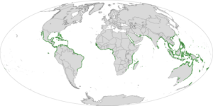
By Laura E.P. Rocchio The most definitive map of Earth’s mangrove forests has been created with Landsat data. A group of scientists, led by Chandra
A single, huge, violent storm that swept across the whole Amazon forest in 2005 killed half a billion trees, according to a new study funded
• A recently published Nature Geoscience article by Ruth DeFries et al. reveals that urban pressures (for food and resources) have replaced subsistence farmers as the leading
Source: Group on Earth Observations “The only way to measure forests efficiently is from space,” Group on Earth Observations (GEO) director, José Achache said referring to
A new set of vegetation maps for five islands of the Caribbean Lesser Antilles, including Grenada, St. Kitts, Nevis, St. Eustatius and Barbados, appear in
Contributor: Gregory Asner A new regional study shows that land-use policies in Peru have been key to tempering rain forest degradation and destruction in that country.
