By Laura E.P. Rocchio

Dr. Yuyu Zhou is a physical geographer at Iowa State University. Here is what he shared with us about the research he presented last Tuesday at #AGU19:
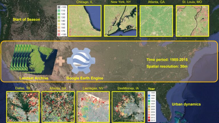
Monitoring annual dynamics of urban landscape and vegetation phenology in the conterminous United States using the full archive of Landsat images and Google Earth Engine
Why is it important to monitor how urban environments are changing?
Our changing urban environments have important implications in human activities such as emissions and energy consumption.
Monitoring urban environment change at fine spatiotemporal resolutions can improve our understanding of the ecological and environmental impacts of urbanization.
Although the percentage of urban land is lower than 1% of the total land area, more than 50% of the world’s population resides in urban areas. More people are migrating from rural to urban areas, resulting in significant changes of urban environments.
How does the open NASA/USGS Landsat archive together with cloud processing capabilities (like Google Earth Engine used for this study) better enable the monitoring of urban landscape dynamics and vegetation phenology?
Satellite observations with fine spatial and temporal resolutions are needed to capture the high heterogeneity and dynamics of urban landscapes.
The open Landsat archive provides such data to monitor urban environment changes. However, there are challenges to process massive Landsat images at the regional and global scales regarding computational resources. The advent of the planetary-scale platform of Google Earth Engine provides opportunities to develop and implement algorithms for massive Landsat images at a large scale for monitoring of urban landscape dynamics and vegetation phenology.
How would you describe what’s new about the urban extent and phenology indicator products you’ve developed?
Our products of urban extent and phenology indicators provide new information about urban environments (compared to previous products) regarding their high spatial and temporal details.
The information of annual urban dynamics (e.g., urbanized years and conversion sources) and vegetation phenology (e.g., start of season and end of season) at a 30-m resolution can be derived from our products.
What potential uses are there for these products?
Our products can be of great use for relevant urban studies, such as urban sprawl modeling and pollen-allergy research.
The urban dynamics product provides one of the key pieces of information needed for developing urban growth models and evaluating the impact of urbanization on human activities.
The phenology indicators product shows great potential in investigating human-environment interactions, such as the response of vegetation phenology to urban heat islands and the implications of phenology change for the duration and severity of pollen season.

Co-authors:
Xuecao Li
Iowa State University
Ghassem Asrar
Pacific Northwest National Laboratory
Zhengyuan Zhu
Iowa State University
Lin Meng
Iowa State University
This study was funded by the NASA ROSES INCA Program (NNH14ZDA001N-INCA)
Any use of trade, firm, or product names is for descriptive purposes only and does not imply endorsement by the U.S. Government.
Further Reading:
+ As Cities Grow, So Does the Urban Growing Season
+ Landsat at the 2019 AGU Fall Meeting
Anyone can freely download Landsat data from the USGS EarthExplorer or the LandsatLook Viewer.


