
Mosquito Meets MODIS & Landsat: South Dakota Fights West Nile Virus
Source: NASA Video @ YouTube South Dakota is the U.S. hotspot for West Nile disease. Scientists and public health officials there developed a way to use environmental data from
Letter Contract for Landsat 9 Imager-2 Awarded
NASA has awarded a sole source letter contract to Ball Aerospace & Technologies Corporation, Boulder, Colo., to build the Operational Land Imager-2 instrument for the Landsat 9 project.
79 Landsat Images Provided to International Charter, Dec. 2015
The Charter concept is this: a single phone number is made available to authorized parties providing 24/7 contact to a person who can activate the charter. Once activated, a project manager takes charge. The project manager knows what satellite resources are available, how to task them to collect data, and how to quickly analyze the collected data to create impact maps for first responders. These maps, provided to responders for free, often show where the damage is and where crisis victims are, allowing responders to plan and execute relief support.
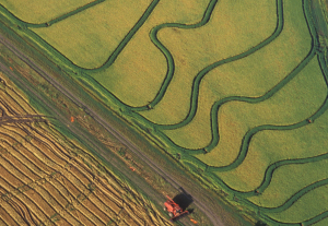
Mapping Rice, Managing Water in Parched California
Liheng Zhong, a Senior Delineator with the California Department of Water Resources is working on a way to map rice fields with Landsat to better manage water use. He presented some of this findings at #AGU15, here’s what he shared with us.
Behind the Rapid Loss of Lakes on the Mongolian Plateau
Shengli Tao, from Peking University, has used the Landsat data archive to map, measure, and investigate the shrinking lakes of the Mongolian Plateau. We spoke to Tao about the work he presented at #AGU15.
Tracking Global Surface Water Dynamics with Landsat
At #AGU15, Amy Hudson, from the University of Maryland College Park, presented a poster about her work to develop a global surface water dynamics map for the years 2000–2014 using data from three Landsat satellites. We spoke with her about this effort.
Measuring Movement at the Bottom of the Earth
Alex Gardner, a Research Scientist at NASA’s Jet Propulsion Laboratory, has used 30 years of Landsat data—some 3 million scenes—to measure the velocity of Antarctica’s ice sheet. He spoke with us about the work he is presenting at #AGU15.
The Mechanics of Meander Migration
Joshua Ahmed from Cardiff University studies how river meanders evolve. Using Landsat data to examine river movement through time, his team has made new observations about river channel change. He presented his findings at #AGU15.
Urbanization Affects Air and Water in Italy's Po Plain
In a recent Eos Project Update, a group of researchers from Italy and NASA’s Jet Propulsion Lab shared the results of their large Po Plain Experiment (POPLEX).
14 Landsat Images Provided to the International Charter in October 2015
The International Charter is a system that supplies free satellite imagery to emergency responders anywhere in the world.

GEOGLAM & the Landsat Connection—Earthzine Takes a Look
There is a global effort afoot to fight hunger and reduce poverty by allowing anyone with an internet connection to see agricultural projections.
Landsat 7 Captures Two-Millionth Scene
Landsat 7, which launched on April 15, 1999, has been continuing to acquire land images worldwide for 16 years. Landsat 5 may hold the Guinness World Record for longest Earth-observing satellite at 28+ years, but Landsat 7 also has an impressive track record. In fact, Landsat 7 has now acquired over 2 million images.
Forest Disturbance History from Landsat Released, 1986-2010
The Oak Ridge National Laboratory DAAC, has just release a Landsat-based forest disturbance history covering the years between 1986 and 2010.
Despite Warming, Landsat Reveals Decadal Slowdowns on Greenland Ice Sheet
Ice sheets are in perpetual motion, making their way downslope like a river. If the amount of snow that an ice sheet accumulates does not keep pace with its loss to the sea, sea level will rise. As temperatures have climbed, positive feedback loops have led to an accelerated loss of ice sheet sections that touch the sea, but in an unexpected twist to the global warming saga, scientists have just discovered a negative feedback loop that is slowing down the Greenland Ice Sheet sections that end on land—a sliver of good news for sea-level rise.
The Loneliest Volcano on Earth
WIRED Magazine’s Eric Klemetti wrote a blog post titled “The Loneliest Volcano on Earth” about Amsterdam Island in the Indian Ocean. In his post, Klemetti used a Landsat 8 image to show the lonesome volcano.
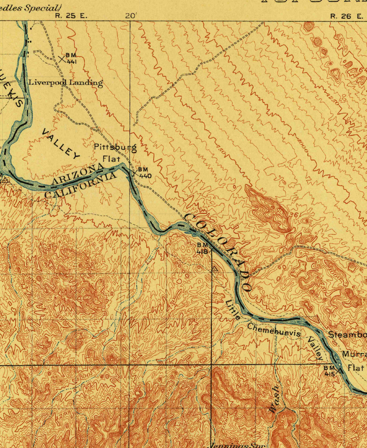
Creating an Oasis in the Desert: Lake Havasu City, Arizona, 1911
Parker Dam was constructed on the California-Arizona border on the lower Colorado River during the 1930s, as part of a project to employ people during the Great Depression, to generate electricity, and to provide water that could be pumped into aqueducts for agricultural, industrial, and residential use in other parts of Arizona.
Visualizing Data—Landsat at the World Economic Forum
The World Economic Forum has published a talk given by Illah Nourbakhsh, professor of robotics from Carnegie Mellon and Matthew Hansen, a remote sensing specialist at the University of Maryland, that demonstrates how visualizing big data can revolutionize the way we understand and imagine the world.
Urbanization Affects Air and Water in Italy's Po Plain
In a recent Eos Project Update, a group of researchers from Italy and NASA’s Jet Propulsion Lab shared the results of their large Po Plain Experiment (POPLEX).
14 Landsat Images Provided to the International Charter in October 2015
The International Charter is a system that supplies free satellite imagery to emergency responders anywhere in the world.
GEOGLAM & the Landsat Connection—Earthzine Takes a Look
There is a global effort afoot to fight hunger and reduce poverty by allowing anyone with an internet connection to see agricultural projections.
Landsat 7 Captures Two-Millionth Scene
Landsat 7, which launched on April 15, 1999, has been continuing to acquire land images worldwide for 16 years. Landsat 5 may hold the Guinness World Record for longest Earth-observing satellite at 28+ years, but Landsat 7 also has an impressive track record. In fact, Landsat 7 has now acquired over 2 million images.
Forest Disturbance History from Landsat Released, 1986-2010
The Oak Ridge National Laboratory DAAC, has just release a Landsat-based forest disturbance history covering the years between 1986 and 2010.
Despite Warming, Landsat Reveals Decadal Slowdowns on Greenland Ice Sheet
Ice sheets are in perpetual motion, making their way downslope like a river. If the amount of snow that an ice sheet accumulates does not keep pace with its loss to the sea, sea level will rise. As temperatures have climbed, positive feedback loops have led to an accelerated loss of ice sheet sections that touch the sea, but in an unexpected twist to the global warming saga, scientists have just discovered a negative feedback loop that is slowing down the Greenland Ice Sheet sections that end on land—a sliver of good news for sea-level rise.
The Loneliest Volcano on Earth
WIRED Magazine’s Eric Klemetti wrote a blog post titled “The Loneliest Volcano on Earth” about Amsterdam Island in the Indian Ocean. In his post, Klemetti used a Landsat 8 image to show the lonesome volcano.
Creating an Oasis in the Desert: Lake Havasu City, Arizona, 1911
Parker Dam was constructed on the California-Arizona border on the lower Colorado River during the 1930s, as part of a project to employ people during the Great Depression, to generate electricity, and to provide water that could be pumped into aqueducts for agricultural, industrial, and residential use in other parts of Arizona.
Visualizing Data—Landsat at the World Economic Forum
The World Economic Forum has published a talk given by Illah Nourbakhsh, professor of robotics from Carnegie Mellon and Matthew Hansen, a remote sensing specialist at the University of Maryland, that demonstrates how visualizing big data can revolutionize the way we understand and imagine the world.
