

Undamming the Klamath
Between October 2023 and October 2024, the four dams of the Klamath Hydroelectric Project were taken down, opening more than 400 miles of salmon habitat.
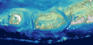
Landsat Plumbs the (Shallow) Depths
Scientists at the U.S. Geological Survey have developed a new way to measure ocean depth, or bathymetry, in shallow nearshore environments using Landsat data.
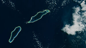
Landsat Takes the Temperature of Atoll Lagoons
Monitoring the temperature of tiny atoll lagoons is important for the local economy and ecosystem. A new study shows that Landsat can help.
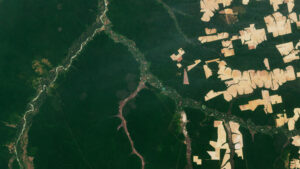
Tracking Losses in the Amazon, Beyond the Rainforest
The Amazon is in trouble. Researchers found that, between 2000 and 2022, the Brazilian Amazon lost about 10% of its natural non-forest vegetation.

Tracking Elephants Across Namibia
In a new study, researchers used GPS tracking data and satellite imagery to map elephant movement in northwestern Namibia, looking for corridors of connectivity.
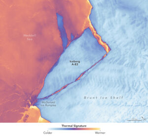
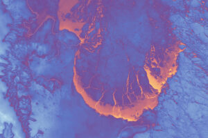
Antarctic Ice Shelf Spawns Iceberg A-83
The Brunt Ice Shelf lost a large wedge of floating ice, the third sizeable iceberg to calve from the shelf in recent years. The TIRS instrument on Landsat 9 captured false-color images of the calving.
Scenes from the Polar Night
Landsat satellites have begun regularly acquiring images of ice at the poles during the winter, with enlightening results.
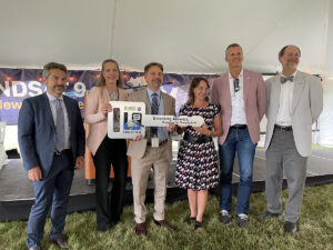
NASA Transfers Landsat 9 Satellite to USGS to Monitor Earth’s Changes
NASA transferred ownership and operational control of the Landsat 9 satellite to the U.S. Geological Survey (USGS) in a ceremony in Sioux Falls, South Dakota on on Thursday, Aug. 11, 2022.
NASA/USGS Landsat 9 Passes Review, Now Operational
Landsat 9, a joint mission of NASA and the U.S. Geological Survey (USGS), passed its post-launch assessment review and is now in its operational phase.
