

 The Landsat 9 spacecraft handles power, propulsion, data storage/downlink, and housekeeping. Northrop Grumman designed and fabricated the spacecraft.
 Landsat 9 was successfully delivered into orbit by a United Launch Alliance Atlas V 401 launch vehicle. The Landsat 9 observatory launched from Vandenberg Space Force Base (VSFB) on Sept. 27, 2021.
The Landsat 9 spacecraft handles power, propulsion, data storage/downlink, and housekeeping. Northrop Grumman designed and fabricated the spacecraft. Landsat 9 was successfully delivered into orbit by a United Launch Alliance Atlas V 401 launch vehicle. The Landsat 9 observatory launched from Vandenberg Space Force Base (VSFB) on Sept. 27, 2021.
The Landsat 9 spacecraft handles power, propulsion, data storage/downlink, and housekeeping. Northrop Grumman designed and fabricated the spacecraft.
Landsat 9 was successfully delivered into orbit by a United Launch Alliance Atlas V 401 launch vehicle. The Landsat 9 observatory launched from Vandenberg Space Force Base (VSFB) on Sept. 27, 2021.
 The Landsat 9 Ground System includes all of the ground-based assets needed to operate the Landsat 9 observatory, including command and control of the spacecraft and management of data transmitted from the observatory. The Ground System was developed by the Department of Interior (DOI)/USGS leveraging existing contracts, with the exception of the Landsat Mission-satellite Operations Center (LMOC), which was developed by General Dynamics Mission Systems (GDMS).
The Landsat 9 Ground System includes all of the ground-based assets needed to operate the Landsat 9 observatory, including command and control of the spacecraft and management of data transmitted from the observatory. The Ground System was developed by the Department of Interior (DOI)/USGS leveraging existing contracts, with the exception of the Landsat Mission-satellite Operations Center (LMOC), which was developed by General Dynamics Mission Systems (GDMS).
The Landsat 9 Ground System includes all of the ground-based assets needed to operate the Landsat 9 observatory, including command and control of the spacecraft and management of data transmitted from the observatory. The Ground System was developed by the Department of Interior (DOI)/USGS leveraging existing contracts, with the exception of the Landsat Mission-satellite Operations Center (LMOC), which was developed by General Dynamics Mission Systems (GDMS).
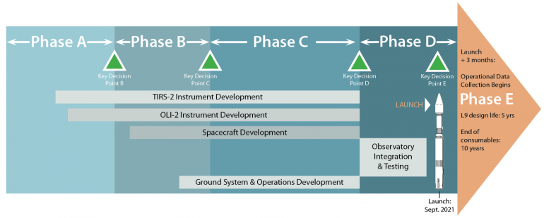
Mission Schedule and Lifecycle
Landsat 9 launched on Sept. 27, 2021. NASA-managed satellite builds have a mission lifecycle that is divided into incremental phases. Phase A is concept and technology development; Phase B is preliminary design and technology completion; Phase C is final design and fabrication; Phase D is system assembly, integration/testing, and launch readiness; Phase E starts after on-orbit operational checkout and ends at the mission’s operational end. Landsat 9 passed Key Decision Point-B on August 17, 2016; KDP-C on December 6, 2017; KDP-D on May 1, 2020; and KDP-E on August 10, 2021. USGS will take over Landsat 9 management for Phase E (mission operations); they will operate the satellite and manage all data downlinking, processing, and delivery aspects. Here’s a more detailed description of the Landsat 9 Development Process.
What Makes Landsat 9 a Science-Grade Satellite?
Scientific studies rely on science-grade instruments—instruments that record information reliably and accurately. Studying long-term changes to Earth’s surface requires carefully calibrated observations to measure subtle changes occurring over decades. The Landsat 9 mission will extend the data record of Earth observations and advance the scientific study of land change and land use into the next half-century. Consistency in Landsat’s spatial resolution, calibration, and spectral characteristics over four decades allows long-term, consistent comparisons of historical and current data.
 Spectral Coverage
For a science-grade instrument, the ability to have broad spectral coverage—the ability to see parts of the light spectrum beyond the visible and near-infrared (VNIR)—is essential. Landsat 9 will collect data in three shortwave infrared bands and two thermal infrared bands, in addition to VNIR. These longer wavelength bands play a vital role in water use measurements (evapotransporation), fire scar mapping, volcanic lava flow mapping, and other indices used for land use monitoring. Because of optical diffraction, the ability to image features at longer wavelengths requires progressively larger telescope apertures. In addition, multiple types of detectors (or even separate instruments) may be required to cover the full spectral range. Thermal detectors must be cooled to very low temperatures (-238º F/-150º C) in order to be sensitive to the low radiance levels emitted at normal Earth temperatures, which in turn necessitates coolers that can cool to cryogenic temperatures.
 Accuracy: Radiometric resolution and geometric fidelity
We use the term “science-grade” a lot when describing Landsat’s instruments. What we mean by this is that the data collected by Landsat satellites have very strict levels of accuracy that they must live up to—the radiation measurements must be reliable for each of the Landsat spectral bands. This reliability is what makes comparisons of Landsat data day-to-day, year-to-year and sensor-to-sensor possible. To do scientific research you need to know you can make accurate comparisons. Radiometric resolution is the ability to measure small differences in radiation over a wide range of brightness levels and geometric fidelity is the ability to know exactly where any given pixel is located. Large optics help by mitigating stray light and ensuring focal plane uniformity (i.e. sameness across the field of the tens-of-thousands of detectors which the telescope focuses light on) to avoid skewed measurements. The Landsat 9 instruments provide radiometric calibration via onboard sources (blackbody, lamps) and a solar-diffuser system for the reflective bands. Additionally, every full Moon, Landsat 9 (like Landsat 8) will be turned toward the Moon to scan the distant lunar surface multiple times. Since the Moon has no atmosphere, it is the perfect consistent source of light to measure–like a gray card for calibrating a camera’s exposure. Data from the Moon is used to both complement and corroborate the results from the other on-board calibration activities.
 Redundancy: Live long and be precise
Landsat 9 must have sufficient redundancy to ensure the collection of science-grade data over a 5-year mission life. This means that many critical components have a redundant counterpart to minimize the risk of a single point failure. For example, Class B missions like Landsat 9 typically have two of almost every kind of electronics on board (e.g., spacecraft computers, communications electronics, attitude control electronics, instrument control electronics), extra reaction wheels, and extra thrusters. In the event that some primary piece of equipment on the satellite experiences an anomaly that impacts its performance, ground controllers can switch over to the backup unit on the satellite to do the job. But implementing redundancy comes at the expense of higher cost and longer development time, and it also tends to make things bigger and heavier. So a critical element of mission design is performing detailed reliability and risk assessments to determine where redundancy might be most beneficial, and then implementing redundancy as efficiently as possible to provide the needed level of reliability.
