

A New and Improved Harmonized Landsat and Sentinel-2 Dataset
In July, 2025, a team of researchers unveiled the Harmonized Landsat and Sentinel-2 (HLS) version 2.0 surface reflectance dataset and algorithms.

Deforestation in Paraguay’s Gran Chaco
The Gran Chaco—South America’s second largest forest—is disappearing. Watch decades of forest change, as captured by Landsat satellites.

One Million Reasons to Celebrate Landsat 9
The USGS Earth Resources Observation and Science Center archive has more than one million Landsat 9 Level-1 products (that’s over 1 billion megabytes of data)!

Undamming the Klamath
Between October 2023 and October 2024, the four dams of the Klamath Hydroelectric Project were taken down, opening more than 400 miles of salmon habitat.

Hispaniola’s Changing Forests
Haiti lost nearly half of its primary forests between 1996 and 2022, with fires and tree-cutting being major drivers of loss, according to a new study.
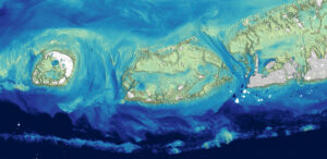
Landsat Plumbs the (Shallow) Depths
Scientists at the U.S. Geological Survey have developed a new way to measure ocean depth, or bathymetry, in shallow nearshore environments using Landsat data.
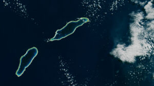
Landsat Takes the Temperature of Atoll Lagoons
Monitoring the temperature of tiny atoll lagoons is important for the local economy and ecosystem. A new study shows that Landsat can help.
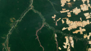
Tracking Losses in the Amazon, Beyond the Rainforest
The Amazon is in trouble. Researchers found that, between 2000 and 2022, the Brazilian Amazon lost about 10% of its natural non-forest vegetation.

Tracking Elephants Across Namibia
In a new study, researchers used GPS tracking data and satellite imagery to map elephant movement in northwestern Namibia, looking for corridors of connectivity.