
Uncharted Exhibit in Sioux Falls
Uncharted, a cartographic art installation, was on display for the 2017 Pecora 20 in Sioux Falls, South Dakota.

Uncharted, a cartographic art installation, was on display for the 2017 Pecora 20 in Sioux Falls, South Dakota.
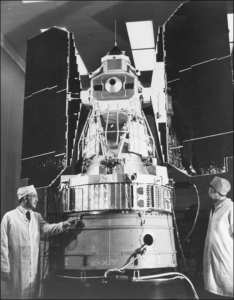
Montanaro and Gerace’s stray light “exorcism” has now placed the Landsat 8 thermal bands in-line with the accuracy of the previous (ghost-free) Landsat thermal instruments.
A NASA study has located the Antarctic glaciers that accelerated the fastest between 2008 and 2014 and finds that the most likely cause of their speedup is an observed influx of warm water into the bay where they’re located.
Using 28 years of Landsat data, an Australian research team has created a continent-wide intertidal zone extent map for the whole of the Australian coast.
In the decades since the Mount St. Helens eruption, scientists have studied the recovery of the ecosystem around the mountain using the Landsat series of satellites.
Descartes Labs released a 3.1-trillion pixel, cloud-free Landsat 8 composite image of the world along with two others based on the European Union’s Sentinel satellites on Feb. 6, 2017.
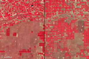
A South Dakota State University research team led by imaging engineer Larry Leigh has completed the first worldwide search for new satellite calibration sites through a partnership with Google Earth. The one-year project was made possible through a $46,000 Google Earth Engine research award.
Rochester Institute of Technology researchers have solved a problem nagging NASA’s Landsat 8 Earth-sensing satellite.
A joint project of University of British Columbia and the Canadian Forest Service—made possible by free and open access to the Landsat archive—has characterized the changes to Canada’s forest between 1985 and 2012.
Today, we are getting richer and more plentiful information about Earth’s land surface than ever before. But amid all of this modern Earth observing splendor, one truism remains: No sensor can image the past.
Government agencies, research universities, independent hackers, coding bootcamp grads, do-good dev shops, swarms of startups, and multi-billion dollar defense contractors are all furiously building Landsat Viewers.
The world has gained 115,000 km2 of water and 173,000 km2 of land over the past 30 years.
A key component of the research is our ability to connect what we see on the ground with what we see from the sky via satellite imagery.
Thanks to a software developer in Australia you can now easily browse through Landsat 8 images on your smartphone.
Google Maps Blog announced on June 26, 2016 that Google Maps and Google Earth have a new cloud-free mosaic based on Landsat 8 data.
At #AGU15, Amy Hudson, from the University of Maryland College Park, presented a poster about her work to develop a global surface water dynamics map for the years 2000–2014 using data from three Landsat satellites. We spoke with her about this effort.
Alex Gardner, a Research Scientist at NASA’s Jet Propulsion Laboratory, has used 30 years of Landsat data—some 3 million scenes—to measure the velocity of Antarctica’s ice sheet. He spoke with us about the work he is presenting at #AGU15.
Justin Roberts-Pierel from the Joint Center for Earth Systems Technology, uses Landsat 8 to detect landslides in the Himalayas. He provided information about his studies at #AGU15. We talked with him about his work.
Alex Burton-Johnson, Martin Black, and Peter Fretwell from the British Antarctic Survey have used Landsat 8 data to create a new rock outcrop map for Antarctica, which will become part of the Antarctic Digital Database. The team presented their research at #AGU15.
Jennifer Rover, a Geographer with the U.S. Geological Survey, gave a talk on an automated method she developed to assess long-term change to Earth’s surface using Landsat at #AGU15.
Capitalizing on the long Landsat data record and the human brain’s capacity to recognize movement, Frank Paul from the University of Zurich has created glacier animations that enable viewers to witness the complex flow of glaciers.
The World Economic Forum has published a talk given by Illah Nourbakhsh, professor of robotics from Carnegie Mellon and Matthew Hansen, a remote sensing specialist at the University of Maryland, that demonstrates how visualizing big data can revolutionize the way we understand and imagine the world.
Imagine you’re flying 438 miles above the Earth taking pictures and collecting information of everything below. What do you see? Now imagine you’ve been doing this non-stop for over 40 years. Do you notice any change?
Using the world’s first global, Landsat-based 30-meter resolution map of tree cover, researchers found that ambiguity of the term “forest” has the potential to create 13 percent discrepancies in forest area maps. While ecologists have long understood the complexity comprised by the concept of “forest”, and while geographers have called for the term to be more uniformly defined across monitoring entities, no one had quantified the scope of the problem.
The European Space Agency’s Sentinel-2A successfully launched into orbit last night from Europe’s Spaceport in Kourou, French Guiana aboard a Vega rocket (10:52 p.m. local time; 01:52 GMT).
In his lightning talk Lagomasino proposed a challenge to help study deforestation by linking satellite imagery and ground-images gathered via crowdsourcing
Dr. Martin O’Leary is a glaciologist with Wales’ Swansea University. He spends most of his time modeling glacier movements and from time-to-time he uses Landsat data to check things out, to get a lay of the land—or glacier. As a pet project he conceived of @LandsatBot, an automated twitter account that tweets interesting looking Landsat 8 images each hour. We recently spoke with Dr. O’Leary about @LandsatBot.

Last Thursday, Amazon Web Services (AWS) announced that it is now hosting Landsat 8 imagery on its publicly accessible Simple Storage Service (S3).
Landsat is a key data input for many products developed and used in water resources, agricultural monitoring, land use and land cover monitoring, forest management, and development planning.
Two years ago today, Landsat 8 blasted off from Vandenberg Air Force Base!
USGS released provisional Landsat surface reflectance products in December. Surface reflectance products correct for atmospheric distortions thereby providing “less hazy” images.
When viewed from space, clouds largely obscure the Earth. It isn’t a matter of time of day, angle or distance. It’s just the way it is – unless, of course, you are gazing at the planet using Google Earth. The story of how Google Earth offers images of the planet — without letting clouds get in the way — began in the foothills of the Santa Cruz Mountains in California.
Orbiting Earth more than 400 miles away in space, far from human view; recording repeated images of land around the globe for more than 42 years; offering customers petabytes of historical and current data for free, the Landsat program of Earth observing satellites could be seen as the personification of the most single-minded office worker — tirelessly systematic, yes, but after so many years, perhaps less than dramatic.
