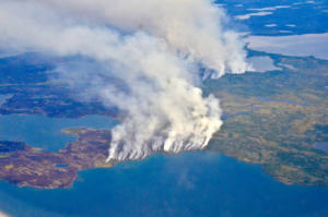
Fire & Water: How Wildfires Can Impact Drinking Water
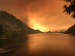
Fires in forested watersheds that support drinking water supplies can introduce contaminants that overwhelm current treatment capabilities. Earth observation data are helping.

Fires in forested watersheds that support drinking water supplies can introduce contaminants that overwhelm current treatment capabilities. Earth observation data are helping.
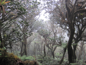
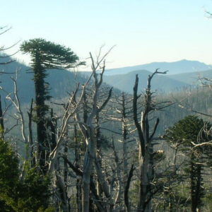
If greenhouse gas emissions continue increasing as they have been, 90% of Western Hemisphere cloud forests would be affected as early as 2060.
Learn more about this rather unusual seasonal and semi-arid cloud forest.
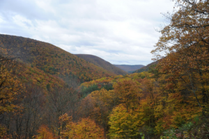
Following changes in long-term forest health around oil and gas wells in the Pennsylvania State Forest.
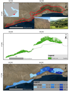
The first study that connects field-measured data with satellite-derived burn severity in this corner of the world.
The 2014 megafires in Canada’s Northwest Territories burned 7 million acres of forest, making it one of the most severe fire events in Canadian history.
Last spring, NASA researchers flew over the Everglades and Puerto Rico to measure how mangroves and rainforests grow and evolve over time, then hurricanes Irma and Maria struck.
The loss of intact forest cover in Myanmar has accelerated in the past decade, according to a study by Smithsonian Conservation Biology Institute scientists and partners.
The data animation based on LandTrendr-derived land cover change illustrates the effects of political boundaries on forest cover as well as the relationship between insect infestations and forest fire behavior.
Tens-of-thousands of Landsat images representing billions of pixels, were used by White and co-authors to map forest wildfire and harvesting on an annual basis and to then characterize the return of forest vegetation following the disturbance.
Looking at the causes of carbon loss in Pacific Northwest forests.
A Landsat-based continuous mapping method to enable better forest management.
Colombia loses hundreds of km2 of rainforest every year to agriculture and industry.
If trees could talk, they would say that Hansen is among their best friends. He is one the world’s foremost forest sentries.
A joint project of University of British Columbia and the Canadian Forest Service—made possible by free and open access to the Landsat archive—has characterized the changes to Canada’s forest between 1985 and 2012.
Valerie Pasquarella, a postdoctoral fellow with the University of Massachusetts Amherst’s Northeast Climate Science Center, recently released a series of new maps showing the magnitude and extent of damage from the current gypsy moth outbreak in southern New England.
A key component of the research is our ability to connect what we see on the ground with what we see from the sky via satellite imagery.
Landsat Science Team member, Mike Wulder, spoke with the International Boreal Forest Research Association last year during their May 2015 conference in Rovaniemi, Finland.
Analyzing a three-decade record of vegetation cover change from the Landsat to compare previous controls on Sierra Nevada forest growth rates and effects of recent fluctuations in water availability since the mid-1980s.
NASA and the U.S. Geological Survey’s Landsat satellite images over the past three decades showed that the severe drought periods recorded since the 1980s have not slowed rapid tree and shrub growth, especially on steep slopes burned recently by wildfires.
Forests are commodities. The biggest driver of deforestation worldwide is the economic value of trees and the land they stand on. With the high demand for agricultural land and wood products, deforestation has become an intractable problem.
A NASA-led team of scientists has developed the first-ever method for detecting the presence of different types of underground forest fungi from space, information that may help researchers predict how climate change will alter forest habitats.
We turned to the remote sensing archive to determine if drought altered forest structure over the course of a decade-and-a-half. We analyzed 22 years of Landsat satellite data to determine changes in forest condition between 1985 and 2012.
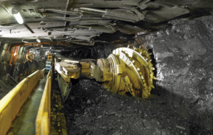
Erin Pfeil-McCullough, a graduate student at the University of Pittsburgh, gave a talk at #AGU15 on insights that she has gained from her research to determine what impacts longwall mining has on forest canopies above as the ground subsides and local hydrology is altered.
Courtney Reents, a graduate student at University of Illinois at Urbana-Champaign, presented a poster on forest disturbance in California at #AGU15.
Chengquan Huang presented a poster explaining where to find U.S. forests that have been undisturbed for last 25 years at #AGU15. His research relied on Landsat to both find these forests and understand forest disturbance trends in the U.S.
The World Economic Forum has published a talk given by Illah Nourbakhsh, professor of robotics from Carnegie Mellon and Matthew Hansen, a remote sensing specialist at the University of Maryland, that demonstrates how visualizing big data can revolutionize the way we understand and imagine the world.
Using the world’s first global, Landsat-based 30-meter resolution map of tree cover, researchers found that ambiguity of the term “forest” has the potential to create 13 percent discrepancies in forest area maps. While ecologists have long understood the complexity comprised by the concept of “forest”, and while geographers have called for the term to be more uniformly defined across monitoring entities, no one had quantified the scope of the problem.
The world lost more than 18 million hectares (45 million acres) of tree cover in 2014, an area twice the size of Portugal, according to new data from the University of Maryland (UMD) and Google released by Global Forest Watch. The data find that tropical forests are in the most trouble, losing 9.9 million hectares (24.5 million acres) of tree cover in 2014 – over half of the global total. A three-year-average shows tree cover loss is the highest it’s been since 2001.
Forest resource managers, natural resource policy makers, and global change scientists need comprehensive, consistent, and up-to-date information on trends in forest cover and condition. This information is essential for understanding carbon budgets, predicting fire behavior, quantifying biodiversity, and hydrologic modeling.
In his lightning talk Lagomasino proposed a challenge to help study deforestation by linking satellite imagery and ground-images gathered via crowdsourcing
