Where Rivers Meet the Sea—Envisioning Science with Landsat
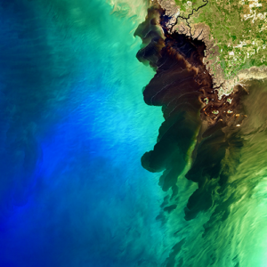
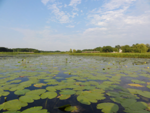
A Landsat 8 image of the Suwannee River meeting the Gulf of Mexico took first place in this year’s Envisioning Science image competition held by NC State.

A Landsat 8 image of the Suwannee River meeting the Gulf of Mexico took first place in this year’s Envisioning Science image competition held by NC State.
A mapmaking app that can fast-track large-scale ecosystem analysis from months to minutes.
This is the first study to document more than three decades of land and water changes across Alaska.
Using a quarter century of Landsat data, geospatial researchers have mapped and modeled how vegetation responds to water availability across the entire Murray-Darling Basin.
Last spring, NASA researchers flew over the Everglades and Puerto Rico to measure how mangroves and rainforests grow and evolve over time, then hurricanes Irma and Maria struck.
NASA satellites are helping Wisconsin develop a clearer picture of its diverse and abundant fauna.
Kelp forests are beautiful but fragile habitats for a wide array of plant and animal species.
The area of mangrove wetlands around the world has been declining over recent decades.
Learn more about the huge citizen science kelp mapping endeavor called Floating Forests.
A method for mapping coral reefs or other benthic habitats over time.
Ways to better estimate the greenhouse gas contributions of wetlands.
Quantifying the impact of historic land-use and hydroclimatic variability on landscape connectivity dynamics across Australia’s breadbasket.
This study examined Landsat satellite data from the past 30 years to track broad land cover change in the Chobe district of Northern Botswana.
High levels of residential abandonment and unchecked vegetation growth in low-income neighborhoods are strong indicators of mosquito prevalence. Higher income neighborhoods are also susceptible to mosquito-borne disease due to the presence of irrigated vegetation, which creates mosquito-friendly habitat.
In the first study of its kind, researchers from the University of Maine have demonstrated that Landsat 8 satellite data can be used to find locations where oysters farms should thrive.
Burned Area Emergency Response teams—one of most important parts of wildfires that you’ve probably never heard of.
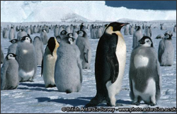
MAPPPD is the first free, open-access Antarctic decision support system that integrates remotely sensed inputs, such as Landsat 7 images and MODIS sea ice data, to provide an assessment of Adélie and other penguin species across the frozen continent.
Using 28 years of Landsat data, an Australian research team has created a continent-wide intertidal zone extent map for the whole of the Australian coast.
Drought and reduced seasonal flooding of wetlands and farm fields threaten a globally important stopover site for tens of thousands of migratory shorebirds in California’s Sacramento Valley, a new Duke University-led study shows.
Approximately 345,000 or fewer chimpanzees remain in the wild, according to the International Union for the Conservation of Nature, a substantial decline from the more than two million that existed a hundred years ago.
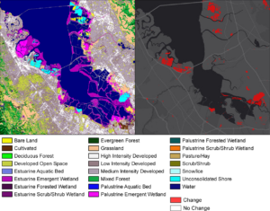
Documenting and protecting wetlands has become crucial to the eight states and two Canadian provinces thronging the Great Lakes.
The hardwood swamp along the Apalachicola River is slowly replaced by bottomland hardwood forest.
A near real-time water resources tracking and decision-support system for the Central Valley of California.
From the Arctic to the Mojave Desert, terrestrial and marine habitats are quickly changing. Satellites are particularly well-suited to observe habitat transformation and help scientists forecast what animals might do next.
Louisiana’s coastal marshes are responding to climate change.
Mangrove expansion has been observed in some subtropical locations around the world.
Scientists at the University of Georgia’s Marine Institute at Sapelo Island have found that the amount of vegetation along the Georgia coast has declined significantly in the last 30 years, spurring concerns about the overall health of marshland ecosystems in the area.
Since record keeping began in 1860, no period has been drier for southeastern Australia than the decade-long Millennium Drought. The lack of rain between 1997 and 2009 led to livestock losses, crop failures, and percentage drops in the Australian GDP.
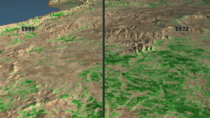
NASA and the U.S. Geological Survey’s Landsat satellite images over the past three decades showed that the severe drought periods recorded since the 1980s have not slowed rapid tree and shrub growth, especially on steep slopes burned recently by wildfires.
The BirdReturns program, created by The Nature Conservancy of California, is an effort to provide “pop-up habitats” for some of the millions of shorebirds, such as sandpipers and plovers, that migrate each year from their summer breeding grounds in Alaska and Canada to their winter habitats in California, Mexico, Central and South America.
A NASA-led team of scientists has developed the first-ever method for detecting the presence of different types of underground forest fungi from space, information that may help researchers predict how climate change will alter forest habitats.
Alex Riter, a graduate student at the University of Maryland College Park, presented her finding on how Hurricane Sandy affected New Jersey coastal marches at #AGU15. We talked to Riter about her research.
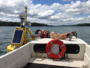
Sara Lubkin, previously with the NASA DEVELOP program, presented a poster at #AGU15 on her work using Landsat data in concert with MODIS data to measure chlorophyll levels in the Chesapeake Bay. We spoke with Lubkin about her work.
